
“Everyone stops by to see the birds, even if it is out of their way,” commented a security guard at the Eaton Centre when I stopped to ask him about the portion of PATH that runs through the shopping mall.
He was referring to the 60 unique fiberglass Canadian Geese that form Michael Snow's “Flight Stop.” The work of art requires visitors to detour from the PATH up to the mall's street level. I have never been able to walk past it without seeing at least one visitor taking pictures of the famous birds.
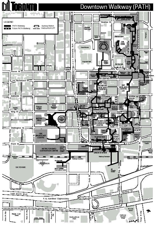
The PATH is a warren of underground tunnels connecting key buildings in the downtown core. With its use, it is entirely possible to grab lunch at the Eaton Centre, and still be back at Union Station in time to catch your train, rain, snow or shine.
According to PATH's website, it amounts to over 10 km of tunnels, all filled with shops, services and places to have a good time. It connects to most of the major downtown attractions, and many of the core's downtown hotels, making it the perfect way to transport delicate masquerade costumes to and from the convention centre. The way is not always shorter than similar street routes, but it presents an unusual side of Toronto that few visitors ever see.
I walked PATH from its most northerly point in the Metro Toronto Coach Terminal, to the Metro Toronto Convention Centre, nearly as far south as the PATH goes. To put it in perspective, the two points are the equivalent of four subway stops, or most of the downtown core, away. The entire trip took just under 40 minutes, perhaps only five or ten minutes more than I spent walking back up to the Coach Terminal using the most direct surface routes available.
Most of the time, many visitors may not even know they are travelling the PATH. Connections between buildings are identified by colour coded signs posted at strategic points in the basement levels of the connected buildings. Along PATH routes, similarly coded fixtures are hung to direct travelers along the cardinal points. To those unfamiliar with the general layout of Toronto however, a pocket map is a must as the signage is sometimes not easily found, and often the change in colour of the floor tiles can be the only indication that you have left one building for another.
Copies of the PATH map are available on their website at http://www.city.toronto.on.ca/path/ or from tourist information booths around the city.
The key portion of PATH for most Worldcon visitors is that linking the two sites where convention events will be taking place: the Royal York Hotel and the Metro Toronto Convention Centre. The two buildings are linked through Union Station and the Skywalk, a wide-laned tunnel also used by Baseball fans to get to the Skydome, home of the Toronto Blue Jays.
Travelers requiring mobility assistance should be cautioned that the PATH connection between the Royal York and Union Station currently requires moving down a flight of narrow stairs, along a small tunnel where the floor slopes at an unusual angle. For these travelers, a scenic tour of Front Street might be a better alternative. Both the Hotel and the Convention Centre are located on Front Street, along with numerous other shops, restaurants and the CN Tower.
The PATH keeps the same hours as the buildings through which it runs. For the crucial connection between the Royal York and the MTCC, that usually means that the connection is closed at midnight until 5 AM, while Union Station is closed for the night. Other buildings, such as The Bay on Queen Street, close earlier. On Sundays, the entire PATH is open, but many of the shops in the basements of banking or office towers are closed. I suppose they need the time to prepare for the onslaught of Monday, when they are flooded under a sea of locals, in addition to the thousands of curious visitors exploring the underground city of Toronto.
-- Sabrina Fried
Last updated: 21 August 2003
Send comments or suggestions to website@torcon3.on.ca
.